Monday 16 June 2008

The journey home

This morning Nigel, Tom and Ian had our final "full Scottish breakfast" and then got on our bikes for the quarter-mile ride to Wick railway station to catch the 0813 to Inverness, the first leg of our long journey back to Cambridge.

Only three of us were travelling back today. Geoff, Mick and Averil were staying another night in Wick and were due to return tomorrow. This was because the website that I used to buy the rail tickets and make the cycle reservations only allowed two cycles on each train from Wick to Inverness. So Nigel and Tom travelled back today whilst Geoff and Averil were due to travel on the same train tomorrow. Ian has a folding cycle and could travel with Nigel and Ian today. Mick is travelling tomorrow, but by an earler 0622 train.

Wick to Inverness

After the debacle we had two weeks ago at Paddington (when we all turned up clutching six cycle reservations for the journey to Penzance only to discover that three unreserved cycles had pinched half the bike spaces, and First Great Western staff refused to do anything about it apart from prevent three of us from travelling) I made sure we arrived early at Wick to avoid any similar reoccurrence. I need not have worried. The conductor checked our cycle reservations carefully as soon as we boarded and in any case there were no other cyclists. Meanwhile Ian folded his Dahon and stowed it neatly in the luggage rack.


Our train from Wick actually had space for four cycles, so two spaces were empty. Evidently the online reservation system was expecting a different train than the two-car "Class 158" that was provided, something that was confirmed by the fact that our reserved seats didn't actually exist on what was fortunately a lightly-loaded train.


The journey to Inverness was comfortable but slow, taking a remarkable four hours for a journey that is only 104 miles by road. Our train even made a side trip to Thurso and back, causing us to stop at one station, Georgemas Junction, twice in the same journey!

The view from the train window was impressively empty and bleak for the first part of the journey; barren moorlands with nothing but low heather and the occasional forestry plantation stretching all the way to the horizon. Later the landscape became less severe and more familiar, as well it might since we passed through many of the places we cycled through on the way up, including Lairg, Bonar Bridge, Dingwall and Beauly before arriving at Inverness on time at 1213.

Inverness to Edinburgh

At Inverness we had a 25-minute interval before our connecting train left for Edinburgh. It was already waiting in the platform when we arrived so we had plenty of time to locate the cycle spaces in this 3-car "Class 170" and load our bikes. No-one asked to see our cycle reservations but there were no other bikes present and the passenger who was sitting in the tip-up seat where the bikes should go moved to another seat without prompting.

Our bikes suitably stowed, we relaxed, dumped our bags in our reserved seats and went back to the station concourse to buy a sandwich and a coffee for lunch.

This train was rather faster than the last, covering about 157 miles in about three and a half hours. However the sun had come out and this was a lovely train ride, taking us down the A9 corridor through Aviemore and Pitlochry that we had rejected as a route for our End to End in favour of the one we took via the west coast. Although we had heard that the A9 route was a "long slog" it was hard to judge what it would have been like from peering out of a train window; it certainly looked pretty attractive in the bright sunshine.

At Edinburgh our itinerary had told us to change onto our third train at Haymarket rather than the larger Waverley station, despite both trains calling at both (the train we were catching would be coming from Glasgow). However a check on the National Express East Coast (NXEC) bikes-on-trains web page warned off a short platform at Haymarket so I suggested changing at Waverley to avoid the risk of the guard's van (with the cycle spaces) not being accessible from the platform. I also reckoned that NXEC platform staff at Waverley would be more likely to know which end of the train we would need.

Edinburgh to Peterborough

Changing at Waverley instead of Haymarket was a good idea, with helpful NXEC staff on the platform telling us exactly where to wait on the platform (for an electric train such as this one from Glasgow, at the First Class end, closer to London). It also gave an opportunity to buy a picnic supper to eat on the train. We met three other cyclists also planning to take their bikes on the same train; they had spent the weekend cycling from Newcastle to Edinburgh along a coastal cycle route and were now returning home. The NXEC staff arranged for those of us bound for Peterborough to board with our bikes first. This was a full-sized train with an electric locomotive puling a dozen or so coaches, and with a guard's van which contained about half a dozen bike racks with straps which we used to stop our bikes falling over, and there was ample room for all of us.

Our bikes safely stowed, we ran along the platform to Coach F and our reserved seats on this very busy train. The 300 mile journey to Peterborough was scheduled to take four hours, and for the rest of the journey I plugged the Nokia 810 into the supplied power sockets and enjoyed the intermittent and slow but free onboard Wi-Fi whilst the countryside of southern Scotland and northern England whizzed by.


It was probably the pleasure of returning home, but eastern England was looking beautiful as I sped through it. York Minster glimpsed between some trees, the parish church of an industrial Yorkshire town, a power station in the distance; they all looked lovely in the evening sunshine.

Peterborough to Cambridge

When I'm travelling back to Cambridge from the north I always feel I'm almost home when I reach Peterborough. Presumably it's the familiar edge-of-the-Fens flatness. And this evening was no exception. So it was with a weary familiarity that I crossed over the bridge to Platform 5 and boarded the 2118 to Cambridge. This was an almost empty three-car "Class 170" and the bike spaces were similarly empty.

Tom observed that at 9.15pm in Peterborough it was already getting dark whereas last night in northern Scotland it has still been broad daylight at 10 O'clock. But by the time we reached Cambridge an hour later, the expanses of Caithness seemed a very long way away.
Sunday 15 June 2008

Day 14: Bettyhill to John O'Groats (50 miles) and Wick (17 miles)


View Larger Map

Today's route took us from Bettyhill along the A836 to Thurso and then to John O'Groats. Although it ran parallel to the coast, for most of the time we were about two miles from the sea and only saw it from time to time.

The weather had promised yet more rain, but apart from a shower whilst we were having breakfast, and a few spots later in the day, we stayed dry for the whole time. It was mostly cloudy but with periodic outbreaks of sunshine. It remained quite windy, but the NNW wind was much less of a problem today, partly because of the shelter provided by the low hills north of the A836 and partly because we were now travelling east, meaning that there was a resolved component of wind behind us.

The improved weather, the quiet and scenic road and our general excitement at having the end in sight made today's ride one of the most enjoyable of the trip. We faced a few steep climbs and descents for the first ten miles or so but then the landscape flattened out and there were few hills for the remainder of the day.

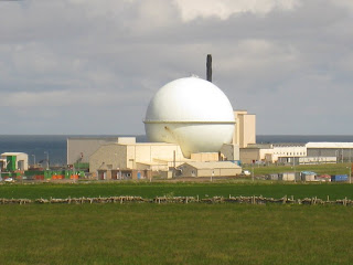
After about 20 miles we passed Dounreay nuclear power station, which according to signs is being decommissioned. We called in, hoping to find a coffee at the visitor centre, but a helpful policeman informed us that the old one had been closed and a new one had not yet been opened. So we cycled on and had a combined coffee stop and lunch stop at a pub in Thurso, about 30 miles from Bettyhill.

For the remaining 20 miles to John O'Groats excitement (and a bit of a tailwind) kicked in and Mick set a cracking pace for most of the way, with Nigel and Averil hanging on behind. When we reached the gates of Mey castle, with about six miles left to JOG, we stopped and waited for the others to catch up.

After a short while we arrived at John O'Groats. Like Land's End this place exists mainly for the tourists but didn't appear to be the tacky tourist trap that Land's End has become. In any case it had all we needed: a signpost to pose for photos in front of (see previous post), and a cafe where we could relax with a coffee whilst phoning family and friends to tell them of our achievement.

We then left John O'Groats and headed south along the A99 for the 17 almost level miles to Wick. We now had the wind completely behind us and made short work of this final leg of our trip. On arrival in Wick we checked into the Queen's Hotel just south of the town centre.

Vital statistics (Bettyhill to JOG): Distance: 50 miles. Average speed: 13.2 mph. Total distance from Land's End to John O'Groats: 969 miles.

Vital statistics (Bettyhill to Wick): Distance: 67 miles. Average speed: 13.8 mph. Total distance from Land's End: 986 miles.

Tomorrow: The journey home

Stop Press: We did it!

At 2.15pm today we finally arrived at John O'Groats:


From left to right: Ian Wright, Geoff Nicholas (Capt), Averil Martin, Nigel Deakin, Mick Cousins, Tom Howes.

Come back later today for the full story...

Today: Day 14 Bettyhill to John O'Groats and Wick

Saturday 14 June 2008

Day 13: Lairg to Bettyhill (45 miles)

To the mysterious northern coast of Britain...


View Larger Map

Today was planned as another short day, for which we were grateful as the weather forecast was for heavy rain and there was a strong northerly wind.


The route was a simple one: from Lairg we would head north along the A836 In the direction of Tongue. This is one of those wonderful Scottish "A" roads shown in motoring atlases as being a "narrow road with passing places". After 21 miles, at Altnaharra, we would turn right onto the B873 for a further 22 miles to Bettyhill.

Perhaps surprisingly, the route was not particularly hilly and indeed the first ten miles was almost completely flat, across an exposed area of open moorland grazed by sheep and interspersed with areas of forestry.

However the ferocious headwind made today's ride quite a struggle, despite the absence of hills, and we were forced to cycle in low gear and rarely achieved a speed much above 10mph, making today's average speed one of the lowest of the trip.

In addition to the headwind, we faced a series of rain showers, though fortunately none lasted more than half an hour and were interpersed with patches of brightness or, more often, dullness.

We stopped for our mid-morning break after 21 miles at Altnaharra. The map showed this as having a hotel, but it turned out to be closed and in administration. So we chewed our bananas and swigged our water whilst sheltering under a tree outside.

Just beyond Altnaharra we turned right onto the B873 and the landscape quickly became more small-scale and pretty, and for a while the wind abated slightly. When we got to Syre, at the junction with the B873, we stopped for a windy roadside lunch. A telephone box provided a handy windbreak, but only for one of us at a time.


Then we continued along the Strathnaver valley for the final dozen or so miles to Bettyhill. Somewhere along here we spotted a jumble sale being set up at Strathnaver village hall so we called in and successfully persuaded them to sell us some cups of tea. Then it was on to Bettyhill and our first view of the sea before checking into the Bettyhill Hotel for the night.


Vital statistics: Mileage: 45 miles. Average speed: 10.8 mph (that headwind...). Total mileage since Land's End: 919 miles.

Tomorrow: the arrival at John O'Groats

Friday 13 June 2008

Day 12: Beauly to Lairg (47 miles)


View Larger Map

We're now about 150 miles from John O'Groats, and have three days in which to get there. This means we can afford to enjoy a couple of shorter and more relaxed days. So we gave ourselves a 10am departure time from Beauly this morning, giving time for a lie in, a lazy hotel breakfast, and for Geoff to book our accommodation for the remainder of the trip.

The A862 north from Beauly was very quiet and almost completely flat as we rode along the neck of the Black Isle (which is not really an island) through Muir of Ord and Conor Bridge.

A couple of miles further we reached Dingwall. Just after leaving Dingwall we had our third mechanical emergency of the trip. Averil's left pedal had come apart. After close examination of the resulting metal puzzle it was clear that a roadside repair would be difficult and so, after a passing local resident remarked that there was a bike shop in Dingwall, a decision was made to go back about half a mile to the bike shop and buy a new set of pedals. This transaction was completed quickly and we were soon back on the road.

The route out of Dingwall involved turning off the A862 and climbing up to a lovely quiet minor road which ran parallel to it but higher, with lovely views over the Cromarty Firth. We noticed that we were following NCR (National Cycle Route) 1 along this section. This might be the reason why we saw at least half a dozen cycle-tourists along this short section, one riding a recumbent with wind fairing.

We stopped in Evanton for coffee at the Cornerstone Cafe, where the friendly staff at this Christian establishment served us complimentary pancakes and jam.

Suitably fortified, we continued to Alness where we turned off north onto the B9176 over the moors of Easter Ross to Bonar Bridge. This required quite a lot of climbing but the main challenge was a quite fierce northerly wind, which forced us down into low gear for most of the crossing of what was probably the most exposed high moorland we had encountered since Shap.

Whilst making our ascent it started to rain gently. At first we thought this was another twenty-minute shower but before long we realised that the rain was not going to go away. So we were crossing high, exposed moorland in steady rain and a fierce headwind, making this 18 miles from Alness to Bonar Bridge one of the toughest of the trip. By the time we reached Bonar Bridge we were cold and damp and so stopped for a very late lunch (it was nearly 3pm) at the first cafe we could find. Hot soup and toasties allowed us to warm up and prepare for the final leg of the day's cycling.

It was only about 11 miles from Bonar Bridge to Lairg. The headwind remained but the rain stopped after a while. We arrived at the Lairg Highland Hotel at about 4.45pm. Given the weather we were glad that this had only been a short day.

Whilst we sat in the restaurant of our hotel the sun came out and we enjoyed a pleasant sunny, evening. It would have been nice to think that this was a good augury for tomorrow. Unfortunately, however, the forecast is for more rain...

Vital statistics: Mileage: 47 miles. Average speed: 12 mph. Total distance from Land's End: 874 miles.

Tomorrow: Day 13 Lairg to Bettyhill

Thursday 12 June 2008

Day 11: Fort William to Beauly (66 miles)


View Larger Map

Yesterday afternoon, Ian noticed that he had two broken spokes on the rear wheel of his Dahon folding bike (which has 20" wheels). However the wheel was not unduly buckled and could ride on to Fort William without difficulty.

This morning Ian visited "Off-Beat Bikes" in Fort William where they made a pair of replacement spokes by cutting down a full-length spoke and re-threading it. Ian then fitted the new spokes in the street outside. Unfortunately a protruding spoke end caused an immediate puncture. After applying tape over the spoke end he re-fitted the now-patched tube and by about 1045 we were at last able to start today's ride.


We were all relaxed about the delay; we have plenty of time to get to JOG by Sunday. The rest of us made good use of the time buying food for the day and booking our hotel for tonight.

We set out north-east from Fort William along the A82, which we would follow along the Great Glen for about 30 miles. We were climbing almost immediately, with clear view of Ben Nevis to our right. We used a short length of smooth, wide, cycle track for the first two miles to Torlundy but it was too good to last and soon dumped us back on the A82.

We then dropped down to Spean Bridge where we started climbing again up to Stronaba. As views of the Great Glen opened up before us we passed the Commando Memorial on our left. Then we descended to Lake Lochy and the most beautifully-situated burger van in Scotland, where we stopped for coffee.


Today was bright with sunny intervals. There was still a northerly headwind but it was relatively light and not much of a problem.

Although this section of the A82 is a main trunk road, traffic was quite light.

After a further hour or so we arrived at Fort Augustus where we had lunch, sitting eating our sandwiches besides the locks of the Caledonian Canal.

After lunch we carried on along the north shore of Loch Ness. I had been expecting to be cycling along the water's edge, but in fact we were high above the lake and the road undulated up and down all the way, giving us a fast and enjoyable ride.

Eventually we reached Urquhart Castle and turned away from Loch Ness to Drumnadrochit, where we made a brief stop to eat a snack. At this point, about 4pm, it started to rain. It was only a short shower, but this was our second rain of the trip. Fortunately it stopped after about twenty minutes and the sun came out.

From Drumnadrochit we took the A833 north towards Beauly. This presented us with our toughest climb so far in Scotland, and perhaps the toughest of the entire trip. At the top we found ourselves in a quite different landscape of heather-covered moorland. At last we were in the north of Scotland. Before long we started descending, however, and the landscape became more pastoral again. After a few more miles we arrived in Beauly, where we checked into the Priory Hotel in the middle of the town. Geoff explained to the hotel management that we were on a charity ride and immediately achieved a £20 discount per room.

Vital statistics: Distance: 66 miles. Average speed: 12.9 mph. Total distance from Land's End: 827 miles.

Tomorrow: Day 12 Beauly to Lairg

Wednesday 11 June 2008

Day 10: Inveraray to Fort William (72 miles)


View Larger Map

We started the day by taking the A819 north out of Inveraray. This started with a steep climb followed by an enjoyable descent to Loch Awe.


The weather forecast for today was sunshine and showers. Ominously the forecast was also for a wind from the north, which would mean a headwind all day. However in the event the wind was quite light and wasn't much of a problem, especially in comparison to the two previous days.

The rain wasn't much of a problem, either. It was quite cool and I wore my rain jacket all day, but the day remained mostly dry and we only had a couple of short rain showers.

When we reached Dalmally we turned left onto the A85 and continued to follow the shore of Loch Awe. After a few miles we stopped for coffee and scones at the visitor centre for Cruachan Power station. When we emerged we found that it was raining - our first proper rain of the entire trip. However donning full rain gear, including overshoes, had the desired effect: after twenty minutes the rain stopped and the sun came out.

After crossing the Pass of Brander we dropped down to Taynuilt and continued to Connel where we turned right onto the A828. A few miles further we stopped to eat our sandwiches beside the bridge over Loch Etive. This was a chilly event due to the cool breeze so after lunch we paused for at the Creagan Inn for coffee and to warm up whilst we phoned ahead to book our accommodation in Fort William.

The remainder of today's ride was straightforward and quite fast, following the A828 and then the busier A82 along the banks of Loch Linhe to Fort William. We were still going strong when, about a mile south of the town, we stopped at our guest house where our rooms enjoyed superb views over Loch Linie.

Overall, today's ride was rather easier then expected due to the reduced wind. It was also perhaps the most scenic yet, along the wooded shores of lochs for most of the day and over low moorland passes for the rest.

Vital statistics: Distance: 72 miles. Average speed: 13.5 mph. Total distance from Land's End: 761 miles.

Tomorrow: Day 11 Fort William to Beauly

The Technology

I've received several requests for a description of how I'm managing to update this blog whilst on tour with the bike.

The key piece of technology I'm carrying is of course a mobile phone. It's a Nokia E65, which is quite small and light and which offers internet connectivity via either GPRS or 3G. On this tour only the slower GPRS has been available. My phone uses the Vodafone network.

The phone allows me to browse the web, read my personal email using an installed gmail client and read my work email using its rather poor IMAP client (though not when on holiday!). It also runs the surprisingly good Google Maps application (which I used successfully to search for a guest house in Northwich).

However the E65 only has a standard phone keypad which makes text entry painfully slow if you're doing anything more than composing a text message. Also the web browser is small and limited.

So for updating this blog I'm also carrying a Nokia N810 "Internet Tablet". This is a small computer about twice the size of a mobile phone with a tiny qwerty keyboard. This runs an operating system called Maemo Linux.

The N810 also has a GPS receiver installed. I'm using this in conjunction with an excellent little program called Maemo Mapper which displays my current location on map tiles cownloaded from Google Maps or Open Street Map.

Whilst the maps on the N810 are too small to be suitable for route planning we have found them a very useful complement to the OS Routemaster 1:250000 paper maps that I have also been carrying, especially when looking for the correct road out of a busy town.

I've been recording a GPS track of this ride, which I might publish after I've cleaned the data up.

As for the photos: I'm also carrying a Canon Digital Ixus 860IS digital camera. This uses a SD memory card. On this ride I'm actually using a mini-SD memory card with a SD adaptor. This allows me to insert the mini-SD card into the N810 to upload photos to this blog.

Tuesday 10 June 2008

Day 9: Largs to Inverary (52 Miles)


View Larger Map

Today had always been planned to be a short day, due to the paucity of settlements between Largs and Fort William large enough to allow us to find a room at short notice. We're also well ahead of schedule, mainly because of some very long days further south. And we fancied a bit of a rest day, given how tough yesterday was.

So we weren't too disheartened to discover that today was just as windy as yesterday. We left Largs after the customary visit to Morrison's supermarket and headed slowly up the A78 and A770 coast road to the ferry port of Gourock, about 16 miles north of Largs. Despite the headwind this was a beautiful road along the shore of the Firth of Clyde.

I passed at least two local buses going in the opposite direction to "Largs via IBM", a reminder of the large computer factory in nearby Greenock.

As we rode into the small ferryport at Gourock the boat to Dunoon was just loading, and we wheeled our bikes straight on. The fare was £3.50; the bike went free on this 15 minute crossing.

After lunch we continued down to the shore of Loch Fyne. We spotted a pub serving coffee and called in for a post-lunch coffee where we had an opportunity to warm up.

Then it was back on the road: first the A815 to Cairndow and then the A83 to Inveraray. This entailed riding up one side of Loch Fyne and then back down the other.


Although it threatened to rain on several occasions it stayed dry all day, with outbreaks of sunshine from time to time. However it remained very windy all day, which meant we were pedalling in low gear most of the time, even when going downhill. We had a headwind when riding NE along the south side of Loch Fyne. And we still had a headwind when riding SW along the north side of the loch. This ability of the wind to blow in both directions simultaneously is probably due the same local geo-tectonic irregularity seen on Electric Brae in nearby Ayr, where rolling objects move uphill.


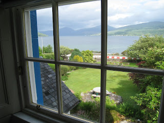
At a very early 3.30pm we arrived at the attractive lochside village of Inveraray where we quickly found accommodation. The photo shows the view from my window.

Vital statistics: Mileage: 52 miles. Average speed: 12.7 mph. Total distance from Land's End: 689 miles.

Tomorrow: Day 10 Inveraray to Fort William

Monday 9 June 2008

Day 8: Dumfries to Largs (88 miles)


View Larger Map

We left Dumfries along the A76 but soon turned off it onto a series of minor roads that runs parallel to it for about 30 miles. This was a lovely ride in the morning sunshine along tiny single-track roads. After about 20 miles we reached Drumlanrig Castle where we stopped for coffee and scones and afterwards inspected the small cycle museum there, which includes a replica of what was one of the first-ever bicycles, built from wood by Kirkpatrick Macmillan.

After coffee we continued along minor roads as far as Kirkconnel, where we had to rejoin the A76. When wed reached New Cumnock we stopped for lunch, which we bought from the village shop and ate sitting on the grass opposite.

Then it was back onto the A76, which we followed as far as Kilmarnock. By now it was getting quite busy and although we made rapid progress along it headwind had picked up and the combination of this and the busy traffic meant that we were all relieved to leave it behind when we got to Kilmarnock.

We went into the centre of Kilmarnock for our afternoon stop. We found a coffee shop in the pedestrianised area and sat outside eating sandwiches and drinking coffee.

Kilmarnock seemed a dismal place, inhabited by dismal, unhelpful people. The sun seemed to agree; it went behind a cloud as we entered the town and only reappeared when we left it. To cap it all, one of a flock of pigeons that seemed to be looping over the town centre decided to, er, drop its load on top of me. Fortunately I was wearing a cap.

We left Kilmarnock on the A335. When we reached the village of Dunlop we turned onto the B706 to Beith and then the B777 to Kilbirnie. By now the headwind had picked up in intensity and was becoming a real challenge. The final section along the A760 to Largs was very hard work, with big gusts of wind slowing us down considerably. By now the weather was noticeably cool and threatening, though it remained dry.

Eventually we saw the sea appear on our left and we started a long descent into Largs, where we checked into our sea front guest house at about 8pm, rather later than usual.

Vital statistics: Distance: 88 miles. Average speed 12.1 mph (low because of that wind). Total mileage from Land's End: 637 miles.

Tomorrow: Day 9 Largs to Inverary

Sunday 8 June 2008

Day 7: Milnthorpe (Cumbria) to Dumfries (90 miles)

Over Shap to Scotland


View Larger Map

We started today's ride by following National Cycle Route 6 from Milnthorpe to Kendal. It was great to be on quiet country lanes again, even if some steep sections meant that I had to use my small chainwheel for the first time since Friday.

Today was the warmest day of the ride so far, with bright sunshine most of the day. However a headwind slowed our progress at times.

After a short stop in Kendal to stock up on food, we rejoined the A6 for the long climb up Shap Fell. This is a long slog up to 1400 feet, though not particularly steep, and it was mainly a case of selecting a low gear and preparing to stay in it for a ten mile climb.

At the top (where motorists parked in the lay-bay were waving to me in salute) we paused to enjoy the view before starting a fast descent to Shap village. There we stopped for takeaway coffee from the village shop. Then on to Penrith for lunch in the main square.

We continued north from Penrith along minor roads to Carlisle, where we decided not to stop: we would keep going and take our tea in Scotland!

The A74 between Carlisle and Gretna is currently being converted to a motorway and cyclists are now prohibited. When construction work is complete an all-purpose road (that cyclists can use) will run alongside. However at present all cyclists have to follow a diversion via the A7 to Longtown and then the A6071 to Gretna. This forced us to ride several extra miles on relatively busy roads.

At Gretna we entered Scotland. At the border crossing we met another group of charity End-to-enders resting besides the "Scotland welcomes you" sign, one of whom kindly agreed to take a photo of us.

We then stopped at a cafe at the "Gretna Outlet Village" before continuing along the B727 to Dumfries via Annan. We faced quite a headwind along this stretch, blowing straight off the Solway Firth.

At Dumfries we checked into our guest house for the night, and enjoyed dinner in a nearby Italian Restaurant.

Vital statistics: Mileage: 90 miles. Average speed: 13.3 mph. Total mileage since Land's End: 549 miles.

Tomorrow: Day 8 Dumfries to Largs

Saturday 7 June 2008

Day 6: Northwich to Milnthorpe, Cumbria (77 miles)

Day Six on the A6


View Larger Map

Our task today was to navigate a course through the sprawling North Cheshire / South Lancashire conurbation without getting lost or stressed by busy traffic.

After the usual morning meal at our guest house we set off north along minor roads to Lymm and a toll bridge over the Manchester Ship Canal.

Then we continued through busy urban roads to Leigh, a grim little industrial town where we stopped for coffee. Then we continued along yet more urban roads to West Houghton where we joined the A6.

We followed the A6 for the rest of the day. Although this is a busy main road which passed through a whole series of urban areas it was wide and for much of the time had cycle lanes. Gentle gradients and long straight sections allowed us to make very good progress. The importance of this road and the ability to ride quickly along it was demonstrated by the presence of numerous club cyclists on the way.

We made rapid progress to Preston where we ate our sandwiches in the main square in bright sunshine and in front of some very imposing Victorian civic buildings.

Then we continued, still at quite a high speed, to Lancaster, where we were welcomed by a sign announcing that the city was "celebrating cycling".


It was only beyond Lancaster that urban England seemed to be being left behind, and we found ourselves at last riding through open country. We were all still going strong when we crossed from Lancashire into Cumbria and arrived at Milnthorpe, about 8 miles south of Kendal.

Worryingly, when we stopped at a supermarket in Lancaster we noticed bars of Kendal Mint Cake (effectively mint-flavoured sugar) in the impuse-buy racks beside the Checkouts.

Today was yet another dry, bright and breezy day, with warm sunshine in the afternoon. It was also yet another day when the weather forecast had been completely wrong...

Vital statistics: Distance: 77 miles. Average speed: 13.7 mph. Total distance from Land's End: 459 miles.

Tomorrow: Day 7 Milnthorpe to Dumfries

Friday 6 June 2008

Day 5: Ludlow to Northwich (81 miles)

or, round the Wrekin with Nigel Deakin


View Larger Map

Breakfast at the Church Inn in Ludlow is worth a special mention today as it was served in an exceptional double-height hall overlooking Ludlow Churchyard. Afterwards we made our way along the B4365 and B4368 towards Much Wenlock.

We were riding through much flatter countryside than on previous days. However a steady headwind prevented us maintaining as high a speed as would otherwise be possible. Apart from the breeze the weather was excellent: dry all day, and warm and sunny for most of the time.

After coffee and walnut cake in Much Wenlock we continued north, skirting the west side of The Wrekin (a prominent hill in Telford) before following mostly quiet roads to Market Drayton.

After an unsuccessful attempt to find a lunch stop in Market Drayton we took our lunch in the idyllic surroundings of Morrison's supermarket.

Then we switched to main roads as we continued our journey north. The A528 to Nantwich was very quiet, and we enjoyed a pleasant half hour relaxing in the late afternoon sunshine in the centre of the town.

Next we took the B5075 and A530 to Middlewich. By now it was the afternooon rush hour and these were very busy, narrow, roads. Not recommended. However by the time we got to Middlewich we were committed and so we continued by the A530 to Northwich and, just beyond it, our beautiful and very comfortable guest house at Pickmere.

Vital statistics: Distance: 81 miles. Average speed: 12.7 mph. Total distance from Land's End: 381 miles.

Tomorrow: Day 6 Northwich to Milnthorpe

Thursday 5 June 2008

Day 4: Chepstow to Ludlow (64 miles)


View Larger Map

We started the day with a fried breakfast at the "First Class Cafe" at Chepstow station, after which we crossed the River Wye back into England on our way towards the Forest of Dean.

We were in Wales for about 14 hours - long enough for me to discover that "parcio beiclau" was Welsh for "cycle parking".

Today, our fourth day, was the day when our legs eventually realised what we had been doing with them for the previous three days. As a result we all found our progress up the B4228 towards Ross on Wye rather harder work than we expected. First of all we had a long climb away from the Severn estuary (with fine views of the old Severn Bridge behind us). Then we had a series of ups and downs through the Forest of Dean which meant that by the time we reached Coleford, 12 miles from Chepstow, we were ready for an early coffee stop.

After leaving Coleford things became easier as we dropped down to the River Wye on our way to Ross.

From Ross on Wye we followed tiny country lanes along the Wye towards Hereford. Somewhere beyond the hamlet of Hole in the Wall we stopped for a picnic lunch, in an idyllic meadow beside the river. As we sat and ate we watched a series of people paddle canoes past carrying large barrels. They were on a management training course, presumably...

When we reached Hereford we stopped at Ian's mum's for tea and cake before pressing on along minor roads to Leominster and then Ludlow.


At Ludlow we're staying in the very pretty Church Inn, which could hardly be more central in a quaint location near the church.

Weather: the forecast was "light showers" but in fact it stayed dry, cool and breezy, with warm sunshine later in the afternoon.

Vital statistics: Distance: 64 miles. Average speed: 12.6 mph. Maximum speed 34.8 mph. Total distance from Land's End: 300 miles!

Tomorrow: Day 5 Ludlow to Northwich

Wednesday 4 June 2008

Day 3: Bampton to Chepstow (88 miles)


View Larger Map

We awoke to clear skies and bright sunshine. Although it clouded over during the course of the day, it remained warm and dry all day, with virtually no wind. Near-perfect conditions for cycling, in fact.

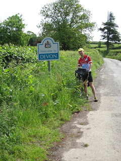
After another Full English Breakfast at The Swan in Bampton (a curious establishment that appeared to have no customers) we set off along the B3227 towards Taunton. Although still undulating the Devon landscape was more gentle than the previous day. A few miles along this road we left Devon behind as we crossed into Somerset.

A few miles before Taunton we turned north to skirt the edge of the Quantocks on the way to Bridgewater. This entailed a few steep climbs (no problem for us now) but allowed us to enjoy a charming landscape of sunken lanes and fine views before descending to the Somerset levels.

When we arrived in Bridgewater we stopped at Morrisons for coffee (two lattees and a danish pastry, Rob). Then across the Somerset Levels to Cheddar. The Somerset Levels offer a totally-flat fen-like landscape - so not completely unfamiliar to us.

After a late lunch in a cafe in Cheddar (baked potato with beans and cheese washed down with two fruit smoothies) we set off again, making a steep climb over the Mendips followed by a descent and then a short level ride to Clevedon on the Bristol Channel.

From Clevedon we continued north along tiny single-track roads to Portbury and the motorway bridge over the Avon.

Somewhere near Portbury I found myself flagging so I brought the group to a halt to allow me to eat a banana and half a sandwich, which perked me up for the remaining ten miles.

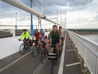
Once over the Avon we contemplated various routes towards the Severn Bridge, deciding in the end to follow a signposted cycle route which ended up being an typical Sustrans magical mystery tour. Eventually we arrived at the Severn Bridge (which was much further than we expected) and crossed over into Wales.


The first town in Wales is Chepstow. We stopped at the very comfortable Chepstow Hotel, where the manager kindly gave us a discount after being told we were doing a charity ride.

Dinner in the hotel was only £5 due to a splendid special offer: I had salmon, potatoes and peas followed by apple pie and ice cream for an additional £3.50 (this is getting to be too much detail), washed down by a couple of pints of Stella.

Overall, a really fine day's cycling.

Vital statistics: Distance: 88 miles. Average speed: 12.7 mph. Max speed: 35.9mph. Total distance from Land's End: 236 miles.

Tomorrow: Day 4 Chepstow to Ludlow

Tuesday 3 June 2008

Day 2: Camelford to Bampton (73 miles)


View Larger Map

Today was dry, bright and breezy, with a Westerly wind behind us for most of the day.

We started the day with a huge English breakfast at our B&B in Camelford. We then got on our bikes and headed along the A39 for a few miles followed by a short stretch of A395 before striking out cross-country towards Holdsworthy. This was a lovely ride along tiny, empty country lanes. A few miles before Holdsworthy we crossed the Tamar and entered Devon.


After tea and cakes in Holdsworthy we continued along the A388 towards Great Torrington. Despite the "A" designation there was very little traffic. After three sharp climbs we reached Great Torrington where we stopped in the old-fashioned main square to eat lunch. Then on along the B3227 to South Molton for coffee before continuing along the same road to the little town of Bampton, where we checked into The Swan for our overnight stay.


Geoff is back! After spending the night at home he put his spare bike in the rental van and drove the 300 miles back from Cambridge to Taunton, where he returned the van and then set out by bike to join us in South Molton. Good to have you back with us, Geoff.

Today was a cracking day. Very hilly, with some tough climbs, but numerous long downhills as well.

Vital statistics: Distance 73 miles. Average speed 12.4mph. Max speed 40mph! Total distance from Land's End 148 miles.

Tomorrow: Day 3 Bampton to Chepstow

Monday 2 June 2008

Day 1: Land's End to Camelford (75 miles)


View Larger Map

We awoke to find West Cornwall enveloped in mist: quite a difference from the previous evening's sunshine. We started the day with another visit to Land's End, with all six of us this time posing for the obligatory photo. Then we zeroed our odometers and set off for Scotland.


It stayed cool and overcast all day, but it remained dry with virtually no wind. After leaving Land's End we followed the A30 as far as Penzance and then took a series of minor roads, first to Marazion (fine view of St Michael's Mount) and then the tiny B3280 via the wonderfully-named village of Praze-en-Beeble to Redruth.

After coffee in Redruth we pressed on, taking the A3075 to Newquay where we stopped for lunch. Newquay is Britain's capital of surf, and we really did see blond young things wandering around with surfboards under their arm.

Three miles out of Newquay, mechanical disaster struck Geoff's bike. The screw that held his rear derailleur to the frame snapped in two, causing the derailleur to fall off and leaving the remains of the screw in the frame.


It looked like Geoff's End to End had come to an end, especially as it looked like only a skilled frame repairer could fix it. After discussing various options, Geoff shortened his chain so he could ride it on a single gear and limped back to Newquay.

The rest of us carried along the A3059 to St Columb Major (where a passing Sustrans ranger guided us through the village) and then along the busy but not-too-bad A39 "Atlantic Highway" to Wadebridge and then Camelford, where we found a B&B for the night.

Somewhere along the way I received a voicemail from Geoff. He was on the M5 near Taunton; he had hired a van or car in Newquay and was on the way back to Cambridge. He is going to pick up his other bike and rejoin us in a few days, perhaps as soon as tomorrow evening. We are all looking forward to having his company again soon.

Geoff's mechanical failure marred an otherwise excellent day of cycling.

Vital statistics: Distance 75.3 miles. Average speed 12.2mph. Maximum speed 36.6 mph.

Tomorrow: Day 2 Camelford to Bampton

Sunday 1 June 2008

Land's End

A smooth train journey to Penzance for Nigel, Ian and Geoff., though Averil, Tom and Mick had to travel on a later service because there wasn't space for their bikes on the London to Penzance train, despite us all having reservations.

Despite drizzle on the way, our arrival in Penzance was greeted by warm evening sunshine. We had a gorgeous ride via Mousehole and St Bunyan to our small hotel in Sennen, pausing briefly for a photostop at Land's End before retiring for a couple of pints at the "First and Last Inn in England" close by.


Tomorrow: Day 1 Land's End to Camelford

We're off!


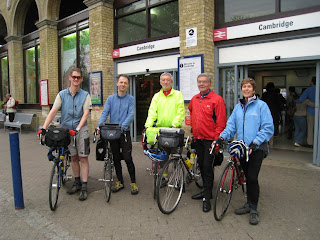
We're on our way, after having been waved off at Cambridge station by Tim B and Andrew. From left to right: Tom, Nigel, Geoff, Mick and Averil. Not in the photograph is Ian, who arrived just afterwards.

We're now on the train to London; when we get to King's Cross we have a short ride to Paddington where we catch the 1257 to Penzance.

Posted using my Nokia N810.

Next: Arrival at Land's End